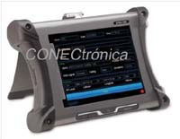
 Adler Instruments presents Aeroflex's truly portable GPS and Galileo positioning simulator, which is easy to use, highly configurable, and economical. It fills a niche market by offering 12 test channels that allow for the creation of three-dimensional simulations. It has been designed to be software-updatable. Other features include:
- GPS signals: L1, L1C, L2C, L5.
- Galileo signals: E1, E5, E5a, E5b, E6.
- Simultaneous simulation of GPS and Galileo.
- SBAS satellites: WAAS/EGNOS L1, L5; MSAS (under upgrade) and GAGAN (under upgrade).
- Static or dynamic simulation of several sections.
- Available in 6 and 12 channel versions, upgradeable, (RAIM compatible).
- SV (Satellite Vehicle) programmable.
- Date and time referenced to UTC or by the user.
- Direct connection to the receiver or via antenna coupler.
- Large touchscreen with a really intuitive interface menu.
- Interface for USB/LAN remote control.
- NMEA 0183 data input.
Channels: The six-channel configuration allows for 3D positional simulation, with five channels for RAIM operation and one channel dedicated to SBAS, WAAS or EGNOSS simulation.
The twelve-channel configuration allows the same capacity as the six-channel configuration, with six additional channels, allowing you to select any combination of SV.
System: The 3D simulation can be defined by the user, in latitude/longitude/altitude format or by 3D position, dynamically simulated using a 50-point scheme. Up to 20 navigation plans can be stored and recalled by a user-assigned name. A built-in GPS receiver allows simulation in the form of range drift, heading, and altitude relative to the equipment's current position.
SV (Satellite Vehicle) Selection: The two GPSG1000 configurations allow mixing GPS and Galileo satellites. (Galileo codes can be renewed by uploading a text file).
Points: 3D space points, with range or altitude, are calculated automatically. Trajectory changes are calculated to simulate real-world navigation; that is, the point uses actual rates per turn for altitude changes when climbing or descending. Points can be defined in LAT/LONG format or by directly referencing data from a specific airport or city.
SBAS: WAAS/EGNOS/MSAS/GAGAN satellites can be selected manually or automatically based on the simulated position. *Coming soon.